The circumstances surrounding this Mount Muhabura expedition were unique. In essence, a friend who had hiked the mountain, proposed we head out and give it a try, since were in Kabale at the time. (Kabale is located about 409 km from Uganda’s capital Kampala). The idea resonated well, given the fact that we had already toured most of the other sites around the area during our stay.
On the eve of the hike, we had a team of 12, ready to take on the mighty Muhabura mountain. I should say we were a diverse lot, with different expectations, however we all had a shared goal of summiting. The team arrived in Kisoro town in three groups with the last one arriving around 9pm in the night. I had traveled to Kisoro about three times before, and always enjoyed having stop overs at the designated points; Bunyonyi lake view and Mount Muhabura view point. This is time we were going to hike up this conical shaped distinctive physical feature. Upon arrival, there was a bit of catching up, part of the group decided to call it a night, since we were to get up early at dawn. The others decided to push the merry making late into the night.
We set off by 6:00am with our packed breakfast and snacks. There is a distance of about 9 km from town to the base camp which also acts as the information center. The camp is about 2,380m therefore we had a warmup hike through the Bufumbira community before we could get briefed. The community largely depends on cultivating the fertile volcanic soils. You will note that most the gardens have piles of stones or volcanoes, gathered aside to clear up farm land. After about 40 minutes or so depending on the slowest person’s pace we were able to reach base and waited for the Uganda Wildlife Authority (UWA) Park guides and rangers.


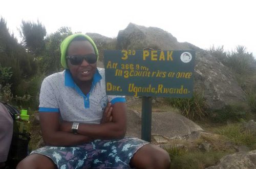
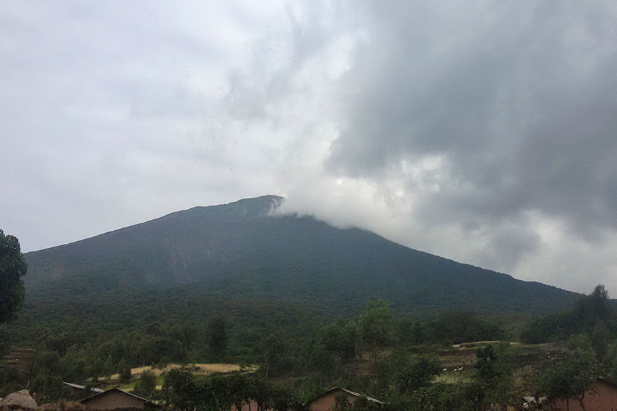
The guides furnished us with a lot of information. There is a famous saying in Buganda, “to travel is to see, and to return is to narrate.” Much of the information about the mountain range and the park was news to my ears. Muhabura or Muhavura as it sometimes known is part of the Mgahinga National Park which covers an area of 33.7km. This particular mountain is the third highest in the Virunga ranges after Mount Karisimbi (Democratic Republic of Congo-DRC and Rwanda) and Mount Mikeno (DRC). On hearing this there were mixed reactions, some were excited for the challenge, the rest hit with the realities of the same.
The guides went on to brief us about other activities of the park, especially Gorilla trekking. Actually, this is among the flagship activities the park offers. The dense forests are a habitant to the endangered mountain gorillas, plus the golden monkeys. These activities to us the enthusiasts were quickly added to our future itinerary.
The guides emphasized the importance of hydrating along the trail and carrying some snacks. The other consideration was the choice of gear especially shoes. We were hiking in July which is predominantly dry, however we were informed that the mountain dictates its own weather. The entire group had improvised gear, a couple jumpers and jackets, rookies precisely, however the shoes we had passed the bar. Am sure the guides had bets on us already, judging from the gear. This is a common occurrence given their immense experience, they can tell who will make the cut and summit.
We ascended at around 8:00am, and along the trail the pace started rationing us into different groups. There is a dense rainforest, which transitions into a bamboo forest as you tower further. The altitude gain is pronounced on this particular hike, every added kilometer is more challenging than the previous. The first rest camp or hut was at 3,116m above sea level(asl). At this point you look down at part of your conquest. Pompi, the Zambian born artiste lyrically says “Maganizo Pa Ndeke” describing a glimpse from the Airplane, indeed at this hut you start having a bird’s eye view. You can easily make out Lake Mutanda, scenic views of Kisoro town and the border town of Bunagana. At this rest point I could only see four members of my team. A couple of students who had started later managed to catch up with the rest of us on the trail.

As we proceeded to the next rest point which was at 3,855m asl, the trail had makeshift wooden ladders which increased demand on the knees. The vegetation is more open, if I remember correctly, it was described as subalpine. The UWA guides are professionals and constantly keep in touch. They emphasize the aspect of turnaround time, for safety purposes, this is to account for people along the trail since this is a one-day hike. We arrived at the second resting hut around 11.30am, one other member couldn’t proceed so the team was further cut to four individuals. I found this resting hut very interesting because you can easily view the path to the summit. Nevertheless, the mountain fogs and clears in bits so you focus on the movement rather those you can see ahead. Towards the summit you encounter some moorland and various lobelia species. The guides will furnish you with a mixture of folklore and tales about the uses of several plants you encounter.

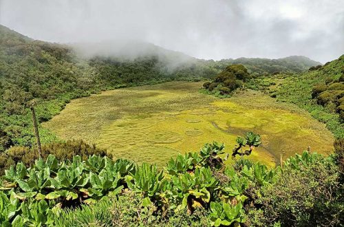
We met the trail from Rwanda towards the summit, however there were no hikers on it that particular day. I was really glad to summit on my first attempt at a mountain. The peak is at 4,172m asl, and here you will appreciate why the mountain is called Muhabura (Muhavura) which translates into “guide” It elevates above the two other ranges in its vicinity. One of the rewards was a crater lake. Swimming in this lake is prohibited, nevertheless the thought did cross our minds. The skyline had its moments you could trace mount Gahinga and mount Sabinyo to the left. Like the name suggests you can easily be guided which direction is Rwanda or Congo. The “guide” is actually in reference to the direction of Mount Rwenzori, where the sun rises.

The summit success rate was extremely low; however, the lessons were quite plenty. After a few cheers’ toasts and victory speeches, we descended. The descent is always demanding on the knees and leg joints, but its quicker regardless. Our hike was about 7 hours on average. Part of our colleagues had abandoned us in anger (these were the lot who had stayed up all night merry making) and immediately traveled back to Kabale. The ones at the base however had tales of their own and were not so beaten up. We headed to town, got a quick shower and relaxed in one of resorts while reminiscing the escapades of the day. This was not only going to be a new found hobby but a lifestyle as well.
Mount Muhabura Experience (3Ps Highlight)
Purpose
Muhabura was my first mountain hike experience. I went along for fun and to try this new activity. However, I learnt a lot. The journey to the top usually starts with enthusiasm, energy and wishful thinking. A long the way, when it gets tough, people start to drop off. Others encourage each other to continue. The circumstances also keep changing, like the weather, in one zone it fogs up in another it shines bright. The lessons of patience, perseverance, and humility clearly demonstrated.
Plan
The plan was simple agree on the date, budget for transport, hike fee, snacks and drinks. There a couple of people who didn’t make it for the trip, this as I discovered later was to be a common occurrence.
Physique
I usually keep a minimum level of fitness. This is through playing several sports like Tennis, volleyball, and at the time I was spreading my wings into golf. The back 18 on a golf course can give you good mileage (about 5 miles, up to 2000 calories burnt up on average) Walking is one of those exercising that is very rewarding especially if you are looking into hiking activities.