I have travelled to many parts of Uganda; work, pleasure and curiosity as the main sentiments. Some parts more than others, however the few trips up North and Eastern Uganda are indeed bodacious. Firstly, the Elgon expedition was not on my calendar at the time, it occurred as a result of mixed emotions. In my experience spontaneous travel has its moments. Life ultimately is a summation of these moments.
“Spontaneity is a gateway through which your purpose can emerge-a moment of relaxation when the truth will show itself!”-Srini Pillay.
After hiking the Virungas, my sight was set on the staggering Rwenzori ranges. An excursion of this magnitude dictates a lot of planning and research. A friend recommended I reach out to the Mountain slayers Uganda (MSU). This is an elite group of mostly urban youths that have mastered the art of organizing amazing hikes and other outdoor activities. In their vast experience, they recommended a hike to Mount Elgon in preparation for Mount Rwenzori, and had a team headed for the same, so I decided to tag along. Next, I sold the idea to my Rwenzori camp and they were in agreement, and so we turned our arsenal Eastwards toward Elgon.

The itinerary was 3 nights (2 nights in the mountain) and 4 days. My two colleagues and I arrived at the pick-up spot (Lugogo- Kampala) and joined the MSU crew that had turned up in numbers. More were arriving so we grabbed bites and started breaking the ice with this diverse group. I should emphasize that “vibe” or literally “Njagala vibe!” was to be the mantra of this entire trip. The phrase is about collectively summoning intrinsic positive energy(vibe) and the group had plenty of the same. We set off a bit later than expected, some members were still making up their minds. We had an entire bus, so this can give you an idea of the numbers. Most were already acquainted. Our destination was Budadiri (about 270 km from Kampala) in Eastern Uganda.
We had our first stop at a gas station in the town/city of Jinja. Home to the source of the tortuous River Nile, the second longest river in the world. Experts still dispute this fact; regardless, we still cherish the thought. The sights and sounds of this town are an entire book, and a paragraph may not do it justice. We had a couple of refreshments and proceeded to the next stop. Mbale city was our next stop. A jewel in the East. The “Gisu” are the predominant tribe and their culture is extremely rich. In the town suburbs some foot cliffs of Elgon are visible. We had a couple of guys to pick up, so we doubled up the time to do some last-minute shopping.
We hit a murram road shortly after departure from Mbale, then arrived at the Uganda Wildlife Authority (UWA) information center in Budadiri after a couple of hours. Our first night was to be spent in the vicinity. The accommodation was next to the office with camping or shared hostel options. A delicious heavy meal was served for dinner. Uganda has a lavish cuisine, especially when you venture into the countryside. The servings are fresh, especially the fruits and vegetables. After a couple of chats and shared experiences, it was lights out.
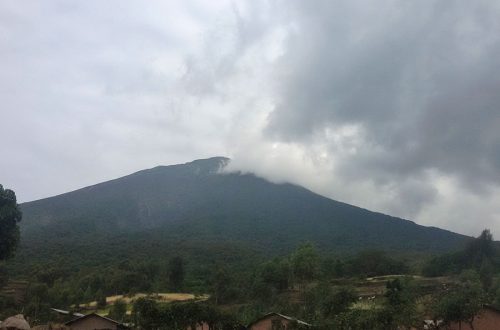
Early the next morning we had a brief about the park and the Sasa trail hiking experience. The UWA rangers doubled as guides, so given our numbers we had one major brief. The Sasa trail adopts a community-based tourism model, implying that the park exists in harmony with human settlements especially on the boundaries. The mountain is the heart of the Mount Elgon National Park area. The conservation area is both extensive and trans-boundary, under park authorities both in Uganda and Kenya. It has been declared a UNESCO Man and Biosphere Reserve.
We improvised Matatus (Mini-vans) to reach uphill where the trail starts. The community members in a coordinated group provide chefs, porters and manpower to tourists headed for the hike. This was a record high for them since each person was allocated a porter. The porters arranged the foodstuffs, luggage, chickens, goats, gas cookers among other items to take up the mountain, at which point I could picture an upcountry market day. The community is always pleased to welcome indigenous tourists.

The first stage was a hike through the human settlement to an altitude of about 2000m asl(meters, altitude above sea level). There was a chance for indulging in some agro-tourism. The community (Bumasola village) mainly cultivates bananas, maize and beans on subsistence scale. The main cash crop is coffee, Arabica coffee in particular dominates. After a stroll through the settlements, we approached the mountain base, which marks the national park boundary. The lofty Mudange cliffs were clearly visible. The porters were faster and led the pack. Watching the vertical ascent of different groups brought shivers, but provided an opportunity to look forward to the challenge.
The park authorities had a team of builders working on a new flight of ladders, so we had to use the old improvised ones. This spot is called the “wall of death”. Getting up each level meant being on all fours in some sections, any loss of balance meant kissing the wall of the cliff, however it could be navigated carefully. This nickname originated from tales of smugglers in the times of commodity scarcity who whilst doing boarder trade, risked and took this route from neighboring Kenya, crossing into Uganda carrying heavy loads. Some of these fellows lost their lives at this point. The trade was popularly known as “Magendo”. After this thrilling experience, we emerged at the summit of the cliffs (about 2,300m asl), with a magnificent panorama of the greater Eastern Uganda landscape. After a short break, we proceeded towards a dense montane forest. A heavy down pour commenced, which we had to bare till the next stop.

The first rest point was at Sasa river camp (2,900 m asl), luckily there was a warm lunch and hot tea. We managed a change of gear and proceeded. The tropical vegetation cover dominates and over 270 herbal species, some with medicinal value identified by experts according to the guides. They emphasized that the region is a sanctuary for bird lovers. A survey documented over 296 bird species. We saw some monkeys on emerging out of the dense forests then made a couple of ascents to a registration point. The Sasa patrol hut (3,300m asl) as it is known also had a military camp for rangers in the vicinity. For accountability purposes, we added our names to the roster and proceeded on the trail. The pace was starting to slow down, my colleague had been affected by the rain. At sun set, we could hear echoes from the campsite and after a few hours we descended to Mude camp.
On arrival, we set up tents at Mude campsite. Located at 3,500m asl, the temperatures can take a drastic turn once the sun sets. Since there was a wave of rain, the conditions were frosty and windy. Some members decided to pitch tents inside the two log cabins, the only permanent structures at the site. The camp is well placed with water and sanitary facilities. The camp site has tropical stunted trees that shield the wind. The campfire was to run 24 hours, acting as the common pot for heating and warming purposes. Most of us went to sleep early to looking forward to the next day.

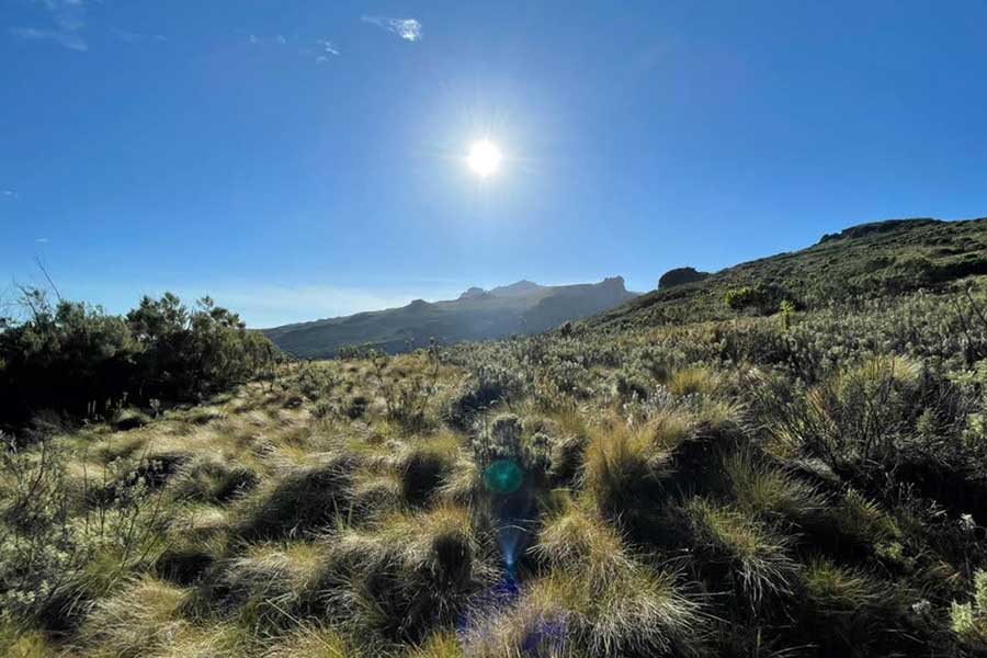
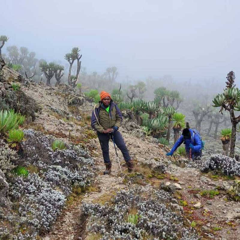
We got up early, had a hearty breakfast and received the day’s brief from the guides. Since the group was big, we had to plan for the day ahead. The last group to return after summiting would determine where the night would be spent (Mude or Sasa river camp), so we left the tents up and much of the luggage. Some members were not able to proceed and remained at the camp site. The hike from Mude is a worthwhile adventure with spectacular views dotted along the path. The camp is amidst a couple of trees so upon exiting, the trail opened up into an alpine zone. The rising sun ambiently radiated into the vast plain with a calm sensation of clean air.
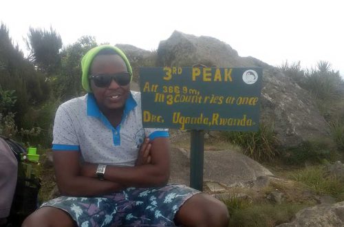
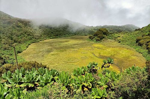
I was able to catch up with the lead group who were resting at a signpost indicating the direction of the Jackson’s pool, caldera hot springs and the Piswa trail. We could not resist taking a moment at the famous Jackson’s pool (4,050 m asl) and admiring the surrounding lobelia plant species. The trail continued with a bit of elevation towards the Jackson’s table. Jackson’s peak of 4,165m is visible, however the trail veers off. Frederik Jackson (a British explorer after whom it is named) initially thought this was the highest peak on the mountain, which was not the case. The predominant tribes along the slopes are the “Gisu” and “Sabiny”. The Gisu are also known as the “Bamasaba”, a name adopted from their founding father “Masaba”, whose personification is this mountain, so they refer to Elgon as “Olusozi Masaba”. The name Elgon nonetheless was derived from the “Elgonyi tribe”, that once lived in the huge caves on the south side of the mountain. The name more precisely “Ol Doinyo Ilgoon” meaning the Breast Mountain.

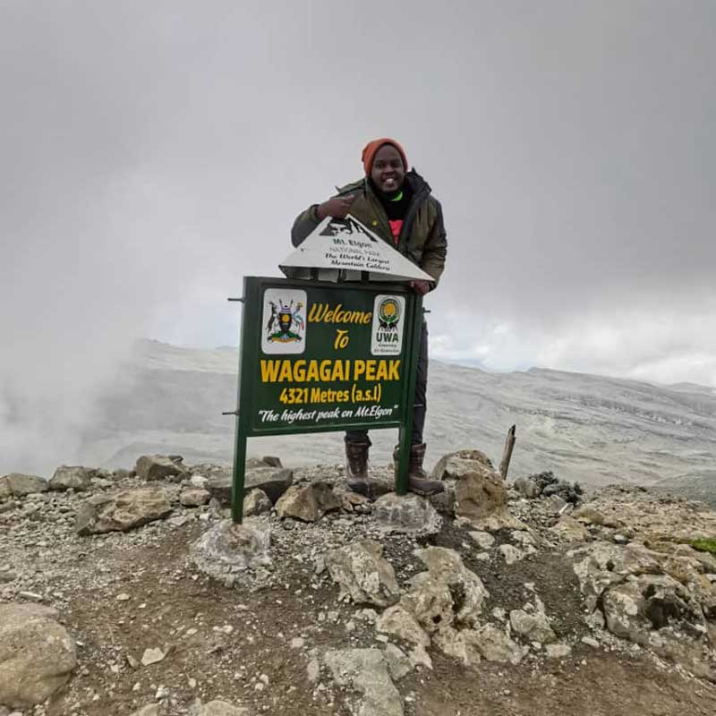
We proceeded eastwards arriving at the ridge of the famous Elgon Caldera. The Suam Gorge is visible here as well. It had a couple of lakes that appeared as ponds due to the distance. The caldera is a razzle-dazzle, stretching as far as the eye can see. It is the biggest mountain caldera in the whole world. A caldera is a large volcanic crater appearing after a major eruption. We maneuvered the caldera ridge to the right, surged upwards towards a rocky dense moorland. This point got misty and cold, and required uttermost resilience, then we emerged at was the summit “Wagagai Peak” (4,321m asl). The peak is unique because it offers an expansive view of the caldera, and the usual sight

The summit rituals of photos, flag reveals, hugs and more celebrations took center stage. While here, were informed that Elgon was once the highest mountain in Africa soaring over Kilimanjaro’s Uhuru peak (5895 m asl), however millennia of erosion led to the downsize.

After the jubilations, we headed back the same way, faster and poised. There was a surprise on the way back to camp near the Jackson table ridge, the porters managed to carry a hot meal for us to enjoy. The energy reserves were replenished as we made it back to Mude camp. The first group had already settled back at camp, and formed a welcoming party. They blissfully cheered on every returning pack and ushered them to the fireplace to catch its beaming warmth. We arranged for some drinks to be shipped from the trading center at the mountain base. After a sumptuous dinner we sat at the fireplace and waited. The chats continued with a struggle against the cold. Once it clocked 10pm, troops started to relinquish, where on earth were the drinks? By midnight only one member was still standing. When the drinks finally arrived, nobody could abdicate the little warmth generated in the sleeping bag for a few minutes of pleasure. This was a hard bargain, thereafter a slight drizzle ensued adding salt to injury. That marked the end of the second night in the mountain. The summit success rate was really high, and the mood in the camp was ecstatic.

At first light, camp was taken down with supersonic speed. The day ahead was long, we had to get to base, continue to the information center and head back to Kampala. The trek back down was quit daunting, the earth was muddy and slippery. Many fell victim, with a number of falls recorded. Honestly, it is hilarious to watch adults resisting the falling reflex, a proper karate set! Luckily no major causalities were reported, just strains, sprains, and fatigue. As for the shoes, the mountain wanted to retain them, most received a heavy beating. After a few speeches, certificates were awarded and we headed off to Kampala. The drinks from the previous night didn’t survive the journey back to Kampala.
3 Ps Highlight (Mount Elgon Experience)
Purpose
This was a preparatory hike for mountain Rwenzori. Looking back, it served the objective perfectly. There was a lot to learn especially the diversity of gear and the balance it entails. I built more resourceful connections, not only for expeditions but for life after as well. Longer hikes also bring out people’s characters and personalities, traits like decision making and humility are put to the test. Great experience.
Plan
Once the dates and resources were secured, the plan was to follow the guidelines from MSU. A great takeaway was the emphasis on gear checks, and this is very crucial to the success of the expedition. The timeline should be at least a couple of months in advance, to have the necessary resources in place.
Physique
A hike with multiple days requires dedication to training. Cardio exercises are paramount, and I focused on walking and running (both treadmill and outdoor). Consistency helps a great deal.